


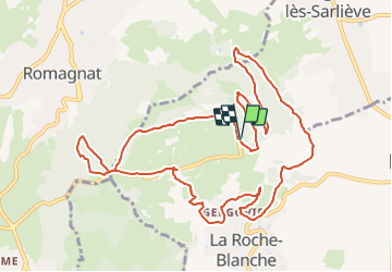
Gergovie le plateau de Gergovie chapelle Déesse 13 km

jeanic63
User

Length
13.1 km

Max alt
731 m

Uphill gradient
427 m
Km-Effort
18.8 km

Min alt
483 m

Downhill gradient
426 m
Boucle
Yes
Creation date :
2021-04-15 09:29:13.568
Updated on :
2024-11-17 10:12:26.016
4h16
Difficulty : Easy

FREE GPS app for hiking
 SityTrail
IGN / Geographical institutes
SityTrail Plus
The world is yours!
About
Trail On foot of 13.1 km to be discovered at Auvergne-Rhône-Alpes, Puy-de-Dôme, La Roche-Blanche. This trail is proposed by jeanic63.
Description
départ plateau de Gergovie vers le musé

Positioning
Country:
France
Region :
Auvergne-Rhône-Alpes
Department/Province :
Puy-de-Dôme
Municipality :
La Roche-Blanche
Location:
Unknown
Start:(Dec)
Start:(UTM)
509863 ; 5063016 (31T) N.
Comments